| Key Benefits & Features: Turn your computer and GPS into a Chartplotter using C-Map Charts, and Software-On-Board. Software-On-Board is a Windows navigation program which, when loaded with C-MAP charts and connected to a GPS, gives real-time on-screen chart positioning and advanced navigation calculations, displayed in easily understood data panels. Automating and simplifying the process of planning, piloting and navigation. Just add a GPS antenna, and use your existing C-Map charts with a USB Card Reader to read NT, Max and SD C-Maps. The GPS pinpoints your precise position on the Earth's surface, Software-On-Board then locates the most appropriate chart from your digital chart portfolio according to the scale and displays it all in a seamless, clear and simple graphical manner on the computer screen. Features - Designed for Touch-Screen use (additional functionality for mouse users)
- Real-time tracking of ship's position and velocity directly on the chart
- Easy chart panning, zooming and level changing
- Tracking of AIS* targets
- Tracking of ARPA Radar* targets
- Visual analysis of wind* direction and strength and advanced optimum upwind sailing tools
- Extensive detail on all chart objects (depths, lights, ports, facilities etc)
- Configurable Anti-Grounding function
- Location specific tide predictions with daily graphs and easy date picker
- One-touch range and bearing lines
- Comprehensive route planning and tracking
- Autopilot* control when tracking a route
- Automatic search route creation (grid or circular)
- Comprehensive Man-Over-Board feature
- Talking PilotAward winning C-Map vector cartography providing global coverage
- Navigate using Routes and Waypoints
- 3D view
- Points of interest
- Animated tides
- GRIB files support
- Tidal range graphs
- Layline display from boat and waypoint
- Read/write C-Map UserCards
- Dead-reckoning mode (including dead reckoning true-wind)
- Voyage replay function
- Plus, much, much more!
* Appropriate hardware devices required Chart Compatibility - C-Map MAX/PC Wide and Megawide Chart CD's
- C-Map NT+/PC Wide Chart CD's
- C-Map MAX C-Cards, MAX SD Cards or NT+ C-Card Chart Cartridges (requires C-Map USB Multi Media Card Reader, see accessories).
Computer Requirements Any recent model laptop or desktop with at least 128Mb RAM, running Windows™ 2000 or newer operating system. (SOB will run with more limited capabilities on most Win98SE systems). GPS Compatibility Almost any GPS manufactured since 1993 should work with SOB. The GPS must be NMEA 0183 compatible. Some older models may require data interface boxes which may no longer be available. Any GPS manufactured in the past 5-8 years is sure to be suitable, and apart from requiring a data cable (a standard accessory), will be pre-configured to work with little or no setup. Modern USB or Bluetooth connected GPS units are suitable for use with SOB. USB Marine antenna available (see accessories) Additional Capabilities Additional standard navigation instruments (NMEA-0183 compatible) are easily integrated: - Autopilot: with just a mouse click or two on the computer chart, SOB will control the ship's course by sending information to the autopilot, steering your vessel precisely to the route or destination waypoint as planned on the computer screen. With appropriate devices connected, the autopilot can also be used to steer your boat to a preset wind angle.
- AIS Transponder/Receiver: now mandatory on all large commercial and passenger ships, the Universal Automatic Identification System uses VHF radio signals to transmit ship's information to all AIS enabled radio receivers in range (typically 20-40 miles). SOB "reads" this data and graphically displays the acquired targets directly on the chart screen. The received information includes: latitude/longitude, course, speed, ship size and type, destination and eta. Navigation aids are also increasingly being fitted with AIS devices to transmit their precise location.
- RADAR: interfaces directly with the computer charts, allowing you to plot an unknown RADAR "blip" transmitted as an ARPA target directly onto the SOB computer chart screen. SOB calculates the other vessel's course and speed; and by extrapolation, can estimate its future position and all CPA data (Closest Point of Approach) and whether it poses a collision potential to your course. SOB will also redisplay the RADAR's cursor and VRM/EBL positions for compatible devices.
- Wind Indicators: Predominantly for sailors, quickly become an indispensable source of information when linked to the SOB program. The wind indicator and anemometer provides the computer with Apparent Wind strength direction. SOB combines this information with your boat's course and speed to determine the True Wind speed and direction.
| 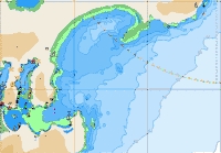 Detailed C-Map Cartography 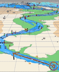
Perspective View with C-Map NT MAX 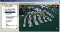
Aerial Photographs available with C-Map NT MAX 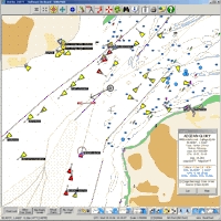
View AIS targets when interfaced with an AIS Receiver / Transceiver 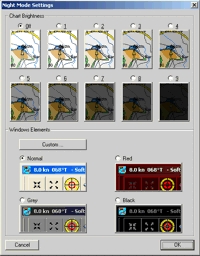
Choose various screen contrast settings for night vision etc. 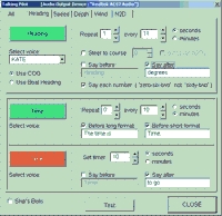
Talking Pilot configuration screen 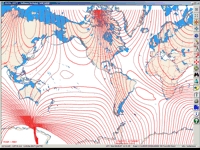
Overlay GRIB files to show details weather information worldwide. 
|

